By
Zafar Gafurov, Researcher – Remote Sensing – GIS, IWMI
Oyture Anarbekov, Country Manager, Uzbekistan, IWMI
Maha Al-Zu’bi, Regional Researcher, Sustainable and Resilient Water Systems, IWMI
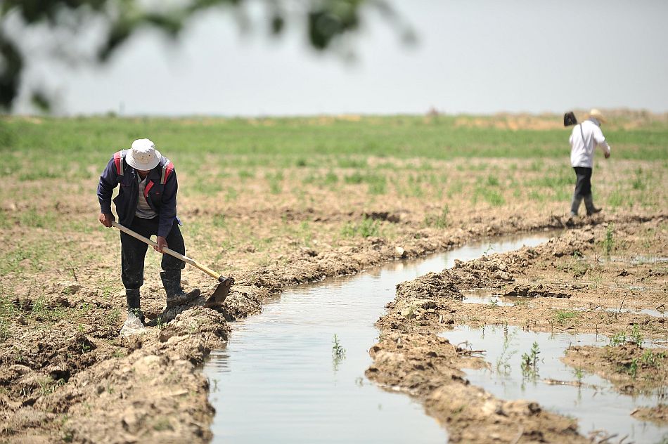
The Central and West Asia and North Africa (CWANA) region is highly vulnerable to the impacts of climate change. The agricultural sector is particularly susceptible, employing 50–60% of the labor force and contributing significantly to the region’s socio-economic development. The CWANA region is already experiencing more frequent – and intense – droughts and heat waves. These higher temperatures and changes in precipitation patterns could reduce crop yields, increase the frequency and severity of droughts and heat waves, and exacerbate regional water scarcity. It is estimated that wheat yields in the region could reduce by up to 30% by 2050, alongside a 25% decrease in water availability in the same timeframe. These impacts are expected to be particularly severe for smallholder farmers, who often lack access to adequate tools such as weather forecasting systems or services like agricultural insurance.
Climate data challenges and opportunities
The limited availability and accessibility of reliable and consistent climate data, inadequate infrastructure, lack of technical capacity and challenges in modeling future climate scenarios pose significant barriers to effective climate change adaptation and mitigation efforts in the CWANA region.
To enhance food value chain resilience in the CWANA region, the CGIAR Initiative on Fragility to Resilience in Central and West Asia and North Africa (F2R-CWANA) aims to improve climate data availability and develop a user-friendly application for weather data extraction. This is crucial because access to and understanding of climate data enables farmers to make informed decisions, improving productivity. Farmers can adjust their agricultural practices based on climate patterns by leveraging climate data to optimize planting schedules, irrigation strategies and crop choices. This can enhance resource allocation, reduce waste and minimize costs, ultimately boosting productivity and building resilience in the face of climate change challenges.
Satellite-based Climate Data Extractor: an innovative weather extraction data platform
F2R-CWANA recognizes the interconnected challenges faced by the region, including climate change, water scarcity, agricultural productivity, conflict and political instability, which have led to increased fragility and vulnerability, particularly in rural areas. To address these challenges, the initiative explores what climate information, data and services agricultural food value chain actors need to manage climate risks in the region. International Water Management Institute (IWMI) researchers have developed the CWANA Satellite-based Climate Data Extractor to enhance the availability and use of remotely sensed information to minimize potential risks associated with floods, droughts and heatwaves in five selected countries: Egypt, Lebanon, Morocco, Sudan and Uzbekistan.
The CWANA Satellite-based Climate Data Extractor is a web platform created and designed to simplify the process of obtaining weather information for the CWANA region. Researchers collect various data, like satellite data, and integrate it into decision-making for automatic data extraction tools. They also use remote sensing – a valuable alternative to ground-based climate data – to monitor how the climate changes over time and identify trends not visible from the ground. Weather data extraction tools can extract valuable information from remote sensing data, climate models and weather stations. This approach can help overcome limitations in accessing consistent and reliable data in the CWANA region.
In the model, users can choose a specific country and timeframe to access monthly temperatures, precipitation data and drought indicators (see Figure 1). To ensure the accuracy and currency of the data, the web platform automatically retrieves weather data from the ERA5-Land archive. This high-resolution dataset covers the entire globe and provides hourly measurements of temperature, precipitation, wind speed and more.
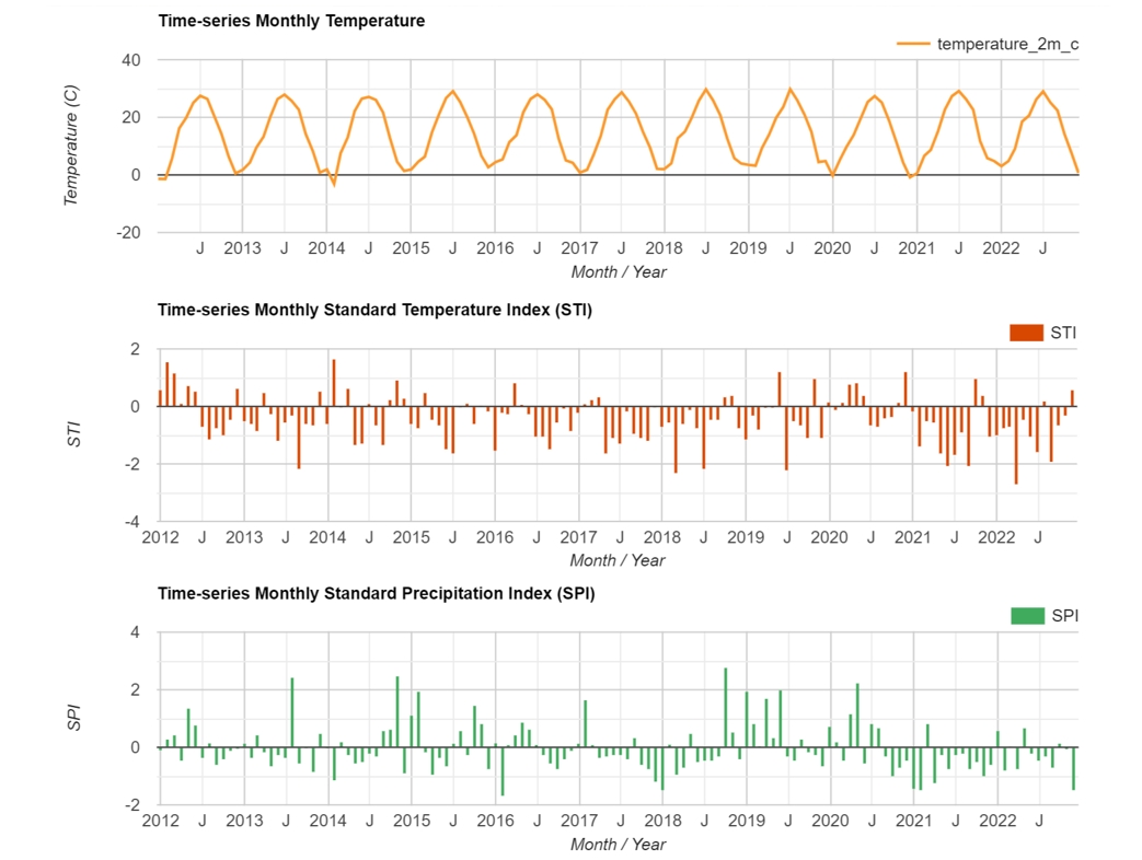
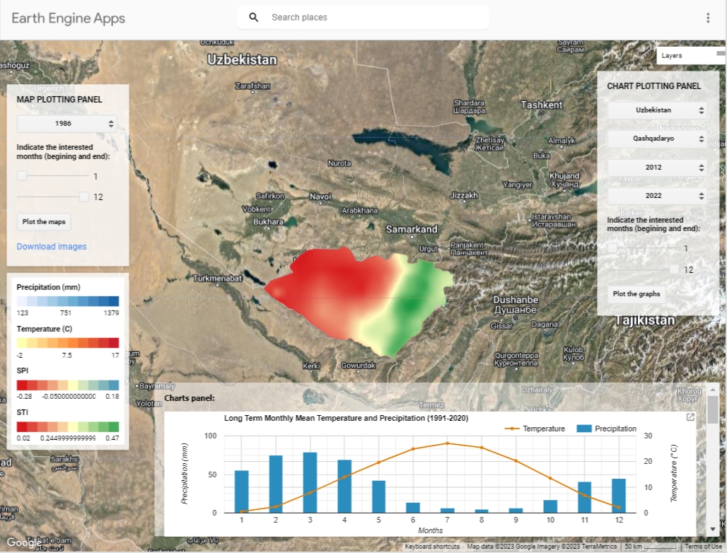
While the accuracy of weather data is essential for reliable decision-making, how it is presented is equally important. The platform not only provides this information in tables and time series graphs, but also generates spatial maps of weather parameters, enabling stakeholders such as policymakers, researchers and others to visualize weather patterns across different regions (see Figure 2).
IWMI is working toward ensuring the accuracy and validation of the weather data used in the CWANA Satellite-based Climate Data Extractor for the five selected countries. It is crucial to be transparent about the limitations of the current version, particularly since a detailed validation and accuracy assessment has only been completed for Uzbekistan. Transparency allows the data users to understand any decisions made – which can help them avoid misrepresenting the information or replicating strategies with undue bias embedded. Acknowledging limitations also encourages further research and model development.
Opening up access to insights
Improving climate data availability, accessibility and management through platforms like F2R-CWANA can enhance the analysis and understanding of climate impacts and provide evidence to inform effective climate change adaptation and mitigation strategies. Visual representations of weather data can aid in comprehending patterns and trends, allowing the effective communication of information to a wide range of stakeholders. By translating data into actionable insights, the CWANA Satellite-based Climate Data Extractor empowers stakeholders to make informed choices that can have real-world impacts. By removing barriers to accessing and interpreting climate data, the CWANA region can take steps toward building a more resilient future for its people and economies.
This work was carried out with support from the CGIAR Regional Integrated Initiative ‘From Fragility to Resilience in Central and West Asia and North Africa (F2R-CWANA)’. The authors thank all funders who supported this research through their contributions to the CGIAR Trust Fund (www.cgiar.org/funders/).