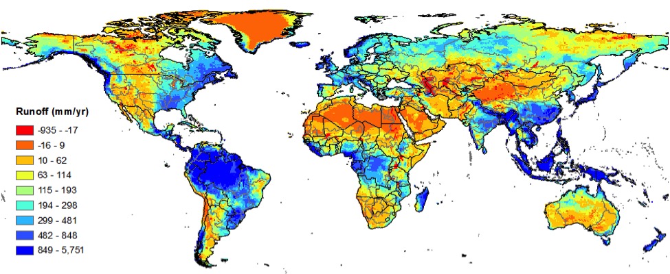
Computer models of the world’s water systems need some new thinking
[pullquote type=”pullquote3″ content=”The last two decades have seen substantial effort in the development of GHMs” quote_icon=”yes” align=”right” textcolor=”#0a8e06″]The last two decades have seen substantial effort in the development of GHMs[/pullquote]
Is it possible to model the world’s water? In an age of unprecedented computing power, what might seem like an insurmountable challenge has become a reality. Indeed there are now so many global hydrological models (GHMs), as they are known, offering such varying insights into water systems, that scientists may be wondering which they can rely on.
Fortunately help is at hand.
Two researchers based at the International Water Management Institute compared the various global-scale models developed over the last two decades. They conclude that some refinements may be needed if the current selection is to prove useful in addressing future challenges. The results have just been published in the Hydrological Sciences Journal and are currently featured as a time-limited open-access paper.

“The last two decades have seen substantial effort in the development of GHMs,” says Aditya Sood, one of the authors of the paper. “So we asked ourselves “which of these models should we be using as the starting point for our own modelling?”. That led us to undertake this review.”
Most of the models looked at are not in public domain and so, to date, it has been quite difficult to undertake a comprehensive comparison.
“Generally speaking the models are based on a concept of balance. Modellers look at the extent to which various factors alter either energy balance or hydrological balance in a system, or both. But despite these similar approaches, there was little agreement in the projections the models made – and that was worrying.”
Kicking the bucket
In part the difficulty arises because the complexities of the models vary based on their objectives and applications. Different factors such as the number of soil layers, number of land-use classifications, crop growth models, irrigation water applications and reservoir storage, are all dealt with in different ways.
One particular concern was variation in the “bucket” approach. These are a commonly used algorithms in modelling that either use a fixed amount of water as a starting point (a “bucket”), or a constantly changing amount (a “leaky bucket”). Adopting one approach or the other greatly changes the way the model works, yet both are used in the various GHMs.
The researchers also looked at input data from satellites. These included information on weather, which is now available at increasingly high accuracy. In general the modellers had used resolutions for weather data that corresponded to half degree squares of latitude and longitude. Most of the GHMs also run on a daily temporal scale. In other words, they only look at how the system changes on a daily basis.
But the researchers felt that these markers of time and space were not necessarily the most appropriate.
“For the long-term assessment of the impacts of climate change and impact on global water and food trade, a monthly temporal scale is sufficient and may simplify the calibration process,” says Sood. “The models also need to move to finer spatial resolution to address some of the global societal issues, but they should not aim to replace more locally focused modelling efforts.”
Model citizens
Progress in GHMs is also dependent on improved access to observed hydro-meteorological data, particularly in developing countries. If we can expand the ‘calibrated area’ of the globe, we could also improve the overall accuracy of GHMs, says Sood. This could be a real fillip for researchers modelling ‘data-poor’ areas, where ground observations will probably never materialize to required levels. Even remote sensing data may not address this gap for some years to come. Hence, simulations will always be needed in such areas.
The authors believe that improving the accuracy of GHMs by all possible means should be seen as a form of international humanitarian aid. However, countries have to be prepared to cooperate by allowing better access to national archives of observed hydro-meteorological data.
“To improve the GHMs, there should be a closer integration of satellite-based products and models,” says Sood. “That would help reduce the internal uncertainties within the models and hopefully give more consistent results.”
“But we would also like to see a more coordinated effort”, he adds. “Too many independently developed models may lead to needless duplication of effort. A broader discussion than the one we have currently undertaken would be welcome.”
Further resources:
View the presentation: How much modelling is enough?
This work is supported by the CGIAR Research Program on Water Land and Ecosystems

