IWMI provides data that will inform response and relief efforts to Super Cyclone Amphan
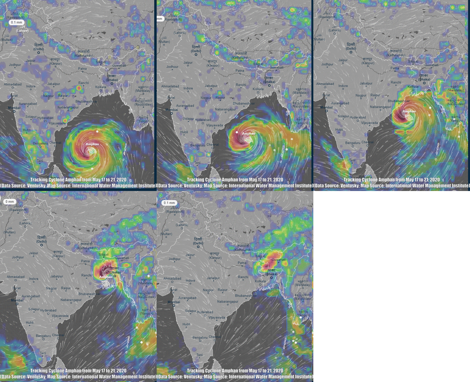
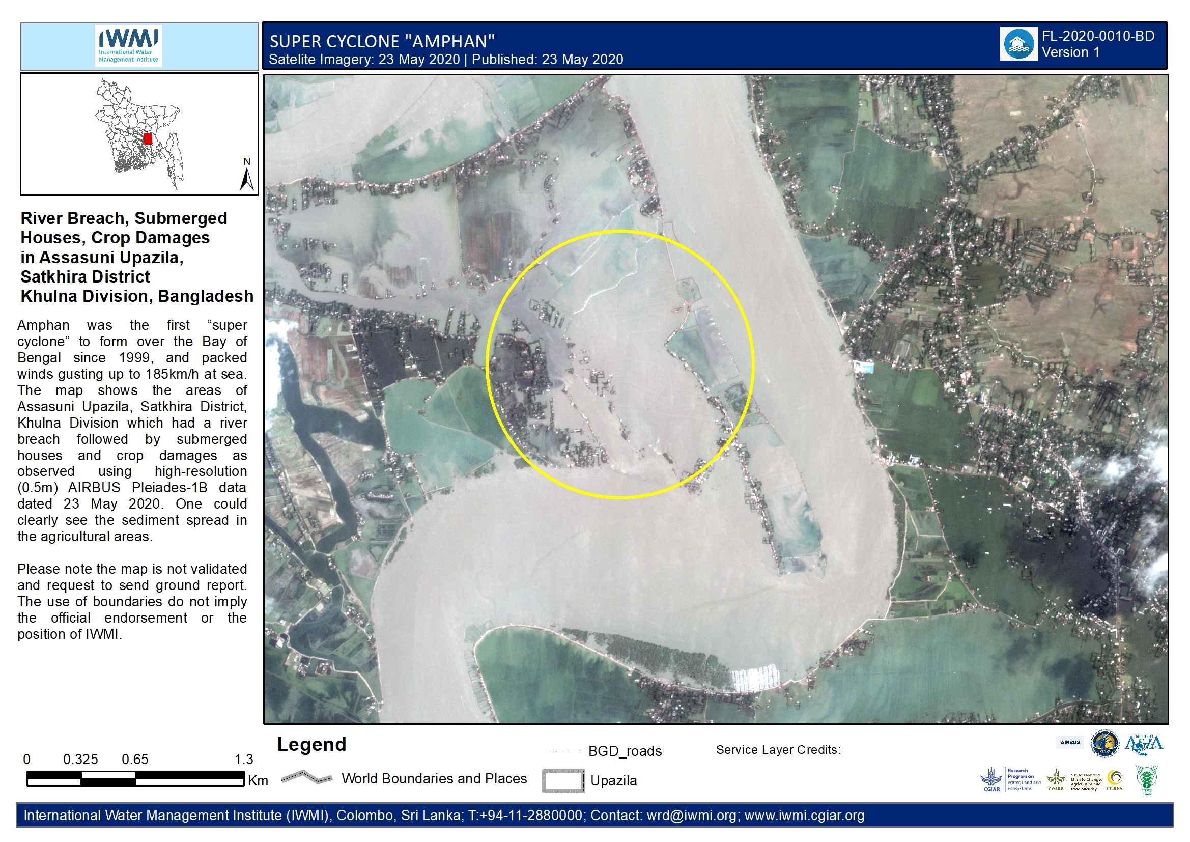
(Colombo, 27, May 2020) Observing super cyclone Amphan evolving in the Bay of Bengal and moving towards crowded coastal areas of West Bengal, India, and Bangladesh, scientists from the International Water Management Institute (IWMI) provided satellite-based maps helping authorities locate and evacuate vulnerable people and identify damaged infrastructure and agriculture.
As local disaster-management authorities rushed to evacuate people before the storm made landfall, IWMI experts supplied them with rapid-response maps based on high-resolution satellite images. These charted the likely trajectory of the cyclone and indicated where it would strike land first. The forecasts proved accurate when, on 20 May between 10:00 and 11:00 UTC, the cyclone made landfall in West Bengal with winds in excess of 185 km/h (100 mph).
IWMI first alerted Sentinel Asia to the impending cyclone on May 16 at the same time raising the issue to the level of the International Disaster Charter which in turn tasked with IWMI with the provision of near-real time satellite data to assist national governments in developing response and recovery strategies.
“The satellite sensors that provide the images are able to ‘see through’ cloud cover, providing a clear overview of cyclone-affected areas, with a spatial resolution of less than two meters,” explained Niranga Alahacoon, IWMI Researcher.
The cyclone ripped apart homes, tore down trees, washed away bridges and left large areas without power and access to drinking water. However, by this time, millions of people evacuated in West Bengal and Bangladesh had been moved to the safety of 12,000 shelters according to Reliefweb, highlighting the difficulties of managing cascading disasters in an area already affected by Covid-19.
In response to requests for assistance from partner organizations in Bangladesh and India, as the storm subsided IWMI scientists provided maps at district-to-block levels, indicating flooded areas and damage to agriculture. They showed, for example, that floods were widespread across urban parts of Kolkata, West Bengal, and had also partly submerged the airport. The researchers have access to more than 600 satellite images and are preparing more than 20 maps combining pre- and post-cyclone satellite data to support governments in identifying breached embankments, and damaged roads and croplands for planning reconstruction.
Amphan was the strongest tropical cyclone to strike the Ganges Delta since Sidr in 2007, and the first super cyclonic storm to occur in the Bay of Bengal since the 1999 Odisha cyclone. It is estimated to have caused more than USD $13 billion of damage in West Bengal, and over USD 129 million in Bangladesh. That makes it the costliest cyclone ever recorded in the North Indian Ocean, surpassing the USD $12 billion record held by Cyclone Nargis of 2008.

As many as 500,000 families in Bangladesh are now homeless, according to the United Nations Office for the Coordination of Humanitarian Affairs (UN OCHA). The West Bengal government said that about 60% of its population was affected. More than 85 people were reported to have died but the figures could have been much worse without the fast and effective actions taken by the authorities. The impacts of so many people needing to use temporary accommodation while coronavirus cases in both countries are high, however, have yet to be ascertained.
“Having access to accurate forecasts from the India Meteorological Department on the cyclone’s trajectory, wind speed, and character at sea, coupled with free access to high-resolution satellite images made available through the international charter and Sentinel Asia, enabled us to create detailed maps that supported states to take critical action to minimize the loss of life,” says Giriraj Amarnath, Research Group Leader of IWMI’s Water Risks and Development Resilience (WRDR) team.
Satellite data is gleaned from organizations such as the Canadian Space Agency, European Space Agency, United States Geological Survey, German Aerospace Center, Airbus, Indian Space Research Organisation, plus commercial space companies Maxar and PlanetScope.
For more information, please contact:
Toby Johnson, Head Global Communications and Knowledge Management
e-mail t.johnson@cgiar.org; tel +94 (0)779425984
The International Water Management Institute (IWMI)
The International Water Management Institute (IWMI) is a non-profit, scientific research organization focusing on the sustainable use of water and land resources in developing countries. IWMI works in partnership with governments, civil society and the private sector to develop scalable agricultural water management solutions that have a real impact on poverty reduction, food security and ecosystem health. Headquartered in Colombo, Sri Lanka, with regional offices across Asia and Africa, IWMI is a CGIAR Research Center and leads the CGIAR Research Program on Water, Land and Ecosystems (WLE). www.iwmi.org


