by Renuka Jeya Raj
The onset of the Southwest monsoon brought incessant rains that lashed the Southwest part of Sri Lanka during the first two days of this month. Although it ended a five-month long drought, the rains took a heavy toll on the country.
The unusually heavy monsoonal rains caused floods, landslides, high winds and lightning in the Colombo, Gampaha, Kalutara, Matara, Kegalle, Ratnapura and Galle districts. About 28,000 people were affected and close to 500 houses were either completely or partly guttered, which forced over 2,500 people to flee their homes and seek refuge in temporary shelters. Flooded roads and railways in several areas brought traffic to a standstill. The navy and air force were deployed to rescue people marooned in floods, and the army to help clear landslides.

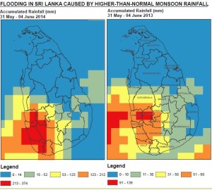
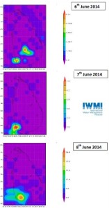
The International Water Management Institute (IWMI) responded promptly to the disaster by identifying extreme floods in the region using flood-mapping tools. Giriraj Amarnath, Researcher – Remote Sensing and Water Resources at IWMI, used Satellite-derived Precipitation Estimates from the National Aeronautics and Space Administration (NASA)-based satellite Tropical Rainfall Measuring Mission (TRMM) to measure the intensity of the rainfall in the different districts in real time. He shared this information with the Sri Lankan Government’s Disaster Management Centre (DMC), UN-OCHA (United Nations Office for the Coordination of Humanitarian Affairs), which is the UN’s umbrella body for disaster relief, and the United Nations Office for Outer Space Affairs (UNOOSA) in Vienna, Austria, to help relief efforts.

“The TRMM satellite visits Sri Lanka every three hours, so we are able to provide immediate flood-impact information,” explained Giriraj. “For instance, the flood map shows that the intensity of the rainfall in Kalutara District was six times higher this year when compared with last year’s monsoonal rainfall. This information, when shared with humanitarian organizations, will increase their knowledge of the floods and help them to decide how best to provide disaster relief.”
The DMC expressed its appreciation for receiving data from IWMI. “This data has good agreement with the ground,” confirmed Srimal Samarasiri of the DMC.
“In the future, we can develop this methodology, provide capacity building and give it to the DMC for their use,” said Giriraj.
Since Sri Lankan skies are cloudy by nature, Giriraj plans to obtain cloud-penetrating images that will enable him to also assess the flood’s impact on agriculture and livelihoods in the country.

