On July 23, a saddle dam helping to contain the reservoir for the Xe-Pian Xe-Namnoy hydropower project in southern Lao PDR failed, releasing an estimated 500 million cubic meters of water downstream and sweeping away 12 villages in Champasak and Attepeu Province. The hydropower project, which was a USD1.2 billion dollar joint venture between Lao, Thai and South Korean companies, wasn’t scheduled to commence operations until 2019, but the reservoir had been filling up since the dams were completed last year and were under particular strain given this year’s heavy monsoon rains.
In the wake of the disaster, International Water Management Institute (IWMI) researchers who are part of the WLE Variability, Risks and Competing Uses research theme have regularly been briefing representatives from the Lao Ministry of Science and Technology (MoST), the National Disaster Management Office (NDMO), the Ministry of Natural Resources and the Environment (MONRE), and the Department of Disaster Management and Climate Change in order to support relief operations and provide maps and analysis on the disaster. In addition to these national entities, these researchers have been talking to the ASEAN Coordinating Centre for Humanitarian Assistance (AHA Centre), FAO, UNOOSA, UNSPIDER, Sentinel Asia and JAXA, and DigitalGlobe to collect, compile and disseminate the most up to date satellite images and analysis in order to help with the disaster relief process.
As part of their efforts to support the Lao Government and rescue operations, the AHA centre compiled a situation update report which uses maps and damage assessments compiled by IWMI researchers. A joint assessment report is also being compiled with input from IWMI and FAO. Discussions are also currently underway for setting up a new emergency response and preparedness package that would help reduce the likelihood of a catastrophe of this magnitude from taking place in the future.
Below is a satellite map showing the pre and post dam break scenario in Attepeu province, compiled using images taken on July 25th by Sentinel 1 to show the water draining from the reservoir.
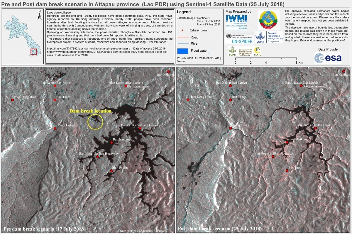
<p>Pre and post dam break scenario, Attepeu Province, Lao PDR.</p>
The next map shows the inundation extent in some of the flooded areas downstream.

<p>Inundation extent downstream of dam failure in Laos.</p>
Read article: UNOOSA and UNITAR-UNOSAT request activation of International Charter for floods in Lao People’s Democratic Republic.
Related contents

Blog Post 

Blog Post