
This post is part of an online discussion on large-scale land interventions that runs through December 20, 2014. Can these initiatives fulfil their promises? Read more here and comment below.
Large scale agricultural expansion is a controversial topic in current development debates. On the one hand, investments in land for agricultural production can potentially bring important economic and social benefits, including increases in food supply and improvements of rural livelihoods. Yet, on the other hand, increasing the agricultural areal often happens at the expense of forests, resulting in biodiversity losses and greenhouse gas emissions.
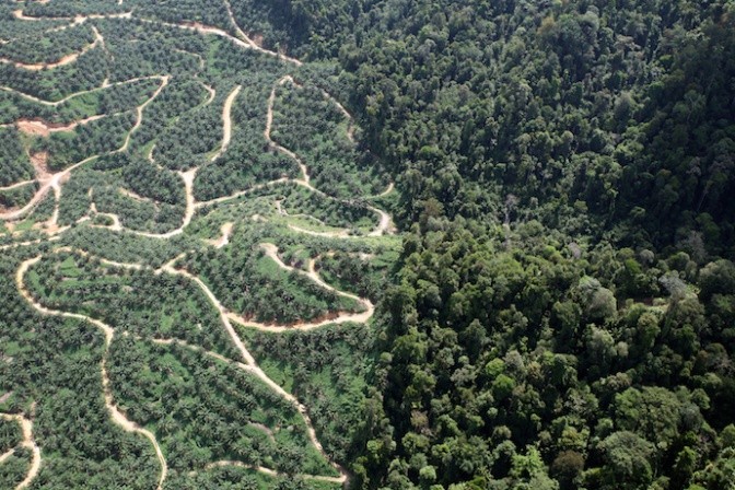 The siting tool is being used to guide land use planning in oil palm - forest landscapes
A key condition to ensure that large scale agricultural expansion can occur sustainably is having in place adequate planning mechanisms which help to balance competing land use goals of agriculture and forestry.
A tool to guide land use planning
Under the REDD+ Energy and Agriculture Programme, SNV has developed a Siting Tool to guide planning processes in forest-agriculture landscapes. With this tool, areas suitable for sustainable agricultural expansion can be identified. It enables the zoning of a landscape for the suitability of a particular target crop, taking into account the impacts of climate change and a number of other indicators related to biodiversity, carbon stocks and ecosystem services.
These indicators can be prioritized based on the outcome of discussions with relevant stakeholders. The tool allows for the output of a Risk Indicator Map of the region under study, highlighting in which areas sustainable agricultural expansion can take place and where further deforestation should be avoided. The Siting Tool can provide strategic information for investors, companies and governments on meeting targets for economic development while mitigating the impact on forests.
The case of Indonesia
The SNV Siting Tool has been tested in North Sumatra, Indonesia, to formulate recommendations on the sustainable development of four commodities driving land use change: coffee, cocoa, palm oil and rubber. For each of these agricultural commodities, results of a biophysical suitability analysis were combined with an analysis of conservation values for the region to generate a Risk Indicator Map, providing a visual representation of the risks and opportunities of agricultural expansion in the landscape. By giving insight in the distribution of conservation values and options for sustainable crop expansion, trade-offs are made insightful that enable informed decision-making on the direction of sustainable agricultural development in the region.
Results from the analysis were most striking for oil palm and cocoa. The Risk Indicator Maps for palm oil showed that areas biophysically suitable for the production of this commodity often overlap with areas of High Conservation Value (HCV). The amount of ‘Low Risk’ areas (i.e. areas which can be developed sustainably without major management intervention) in North Sumatra were very limited.
Cocoa appeared to have the most radical shifts in biophysical suitability over time.
It is anticipated that overall, suitability for cocoa will shift towards areas where production is considered ‘High Risk’ due to the presence conservation values. The introduction of shade trees could be one viable option to reduce the impacts of climate change. The siting tool provides an indication where such a system could be introduced most successfully.
Moving forward
Forests and agriculture are often in direct competition for land and win-win situations are not always possible. The siting tool represents a means to examine trade-offs and can guide the design of integrated forest and agriculture solutions across the landscape. After testing the tool in Indonesia, the tool is now being rolled out globally. The first results show that large scale agricultural expansion can be sustainable, as long as forest land use objectives are carefully taken into account.
Read more:
The SNV Siting Tool
Related contents
Podcast 

Blog Post 
Blog Post 


Comments
Where can I find more information on the siting tool? A contact person? The link of the tool is not working.
I am currently working as an SNV consultant in Water for Growth programme in Rwanda. We think this tool might be useful?
Thank you, Michiel
Hi Michiel--I'm not sure how useful this is, but here's a press release from SNV on this siting tool:
https://www.snv.org/update/snv-siting-tool-fosters-multi-stakeholder-dial...
Add new comment