
Prospects and the Business Challenges
"Thank you for your message. Now I understand my vegetable," texted an Ethiopian tomato farmer. While not a correct request for information, as understood by our SMS system, it was a welcome piece of user feedback.
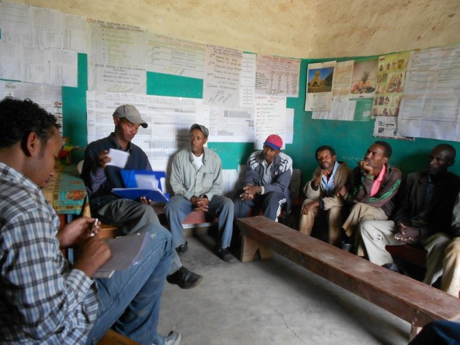 Evaluating irrigation advice via SMS with tomato and onion farmers in Arata Chufa. Oromiya, Ethiopia. Photo: Gijs Simons
With a team comprised of IWMI, eLEAF, DLV Plant and local partners, we have been piloting an innovative project which provides information and advice regarding weather and water requirements to smallholder farmers using ICT for agriculture channels. Executed in Nubaria (Egypt), Gash Delta (Sudan) and Arata Chufa (Ethiopia), the ultimate aim of this IFAD-supported project is to empower farmers to make informed decisions and better manage their land and water resources.
After analyzing user needs, we have implemented an interactive SMS service for providing field specific information and advice in the local languages. By sending simple one-character codes, farmers can request an update of crop growth and water use efficiency relative to their peers. The users can also notify the system of timing and amount of irrigation, and the water balance of each plot is monitored as the basis of on-demand daily irrigation advice.
In addition, online data portals enable local extension advisors to monitor the status of all individual registered fields with weekly maps of nine different crop water parameters for each field. Based on observed differences between farms, or even within a single field, extension advisors can identify anomalies and contact the relevant farmer. The main source of data feeding both the web and SMS information service is high-resolution satellite imagery, with one new image acquired every week.
The potential of this type of services is overwhelming. Africa is the fastest growing mobile market in the world. The number of mobile subscribers has grown by 18% per year for the past five years in Sub-Saharan Africa, while the number of internet users in Africa grew 9 times faster than in Europe over the period 2003-2013. These developments provide a whole new group of people with access to modern communication technology and information services. At the same time, there is a rapidly growing population to feed, while ongoing climate change creates new and often irregular patterns in weather and water conditions.
Developments in satellite sensors and image interpretation are now a proven data source for precision agriculture systems in the developed world. Free and low-cost high-resolution satellite imagery is becoming increasingly available, including NASA's Landsat 8 satellite (2013) and ESA's Sentinel-2 (to be launched in 2014), making scaling up to emerging markets more plausible. The numerous opportunities of ICT services for smallholder farmers are widely acknowledged, with multiple "ICT4D" and "ICT4ag" conferences being organized worldwide, and by government funding programs such as the Dutch Geodata for Agriculture and Water (G4AW) facility.
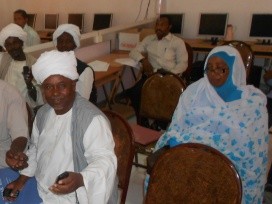 Piloting of sending and receiving SMS message with sorghum farmers during a training session at Kassala University, Kassala, Sudan. Photo: Gijs Simons
In short, the opportunities for success seem to be there. Evaluation results of our pilot show that farmers are generally positive about the implemented information system and its impact on production and resource use, which is an encouraging observation.
Now the real challenge for us, and anyone operating in this field, is to bridge the gap between the innovation stage and a sustainable and reliable information system. Smallholders have indicated their willingness to pay to support such a system: a good start, but realistically these amounts will not suffice to cover the costs of running ICT services and associated user support. To offer continuity to the end users, and to maximize impacts of a system, a solid business model is essential.
Although maybe not an obvious choice from the perspective of traditional development projects, the shortest route to success likely lies in realizing long-term commitment of the private sector. There are several incentives for large food producers to participate. The first one, obviously, is benefiting from the monitoring system themselves. Due to the nature of the satellite-derived source data, large food producers can keep track of a variety of crop water parameters of their fields online against relatively little extra expenses, as long as they are located broadly in the same geographical region as their smallholder colleagues.
In certain areas one could also think of a Green Water Credits-type of model, in which downstream food producers finance upstream management practices by smallholders beneficial to downstream water availability. And then there are general Corporate Social Responsibility objectives, not necessarily related to the firm's core business.
The use of ICTs and geodata for improving crop production, farmer income and resource use efficiency holds huge promise, and it would be a waste to prevent it from getting past the innovation stage.
Related contents
Blog Post 
Blog Post 
Blog Post 


Comments
Nice