


This Thrive Blog was originally an Op-Ed in the Kathmandu Post in honor of World Water Day.
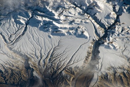
If asked where their water comes from, a typical Nepali might point to nearby Sundarijal reservoir or to the water tankers hurtling down Kathmandu roads carrying loads from distant springs and wells. But where does that water come from? And how do these springs and wells stay refilled with water all year?
The world just marked World Water Day. And around the globe, including in Nepal, water scarcity is an exacerbating problem under climate change. To ensure year-round water availability – we need a scientific approach to protect this crucial resource. Groundwater wells are increasing in urban areas like Kathmandu while reports emerge of declining groundwater resources. Similarly, springs are the primary water source for remote communities in the mid hills of Nepal. Drying up of springs due to changes in climate and land use patterns is a major threat to livelihood.
The maintenance of any water resource is a story that extends far beyond what we see with our own eyes. Rainfall in central and eastern Nepal is sourced mostly from moisture from the Indian Ocean originating in the Bay of Bengal. Western Nepal’s rains originate from both the Indian Ocean and the Mediterranean Sea.
On a smaller scale, pinpointing the source of a local well or spring is complicated because it can be fed by surface water, groundwater, or a combination of both. As many wells and springs are reported to be drying up, identifying the source area can help authorities plan to ensure a steady supply.
In order to identify the source of wells and springs, scientists use a method called “isotope analysis.” This method locates the source of water and can even identify its age.
Essentially, isotope analysis takes the fingerprint of a sample of water by measuring the ratio of heavier and lighter molecules of hydrogen and oxygen. By measuring this, researchers can identify the water’s unique signature. These signatures, when compared with global standards established by empirical studies, can reveal the source of water right down to the latitude, longitude and elevation. It can also determine the water’s age in terms of the duration that water has been in the subsurface and the processes it has undergone prior to reaching the sampling point.
The potential of isotope analysis
Isotope analysis is especially useful in places where there is a lack of adequate information on groundwater and surface water systems. In the long run, it is a relatively low-cost way to help scientists make better judgments about water management by identifying the area from where a certain spring is being recharged or whether the source is surface water or groundwater. This information can help policymakers manage water flows and address water shortage by focusing interventions on actual water source locations.
Using isotope analysis to understand the origins of water resources and identify appropriate water interventions has many precedents especially in South Asia. In Uttarakhand, India, communities have been forced to migrate due to drying up of springs and lack of other sources of water. Isotope analysis has been used to identify ideal recharge areas for these springs and implement recharge ponds that can ensure reliable water supplies to the communities.
Isotope analysis in Nepal
Realizing the potential of isotope analysis for water management in Nepal, the “Building Climate Resilience of Watersheds in Mountain Eco-Regions” (BCRWME) project has successfully piloted the application of isotope analysis for identification of recharge zones for springs sources. The project is supported by the Climate Investment Fund, the Asian Development Bank (ADB) and the Nordic Development Fund (NDF) and is administered by the Department of Soil Conservation and Watershed Management (DSCWM). Leading the pilot research component of the project, the International Water Management Institute (IWMI) has gathered over 400 water samples in two years from Shikharpur and Banlek village in the West Seti river basin, where drying springs are the primary source of water. By identifying recharge areas for springs in BCRWME project areas using isotope analysis, DSCWM’s understanding of the water resource connections and origins is improved. Isotope analysis has explained poor performance of existing recharge ponds located far from ideal areas and provided guidance for future implementation of such interventions. Learning from this project will provide guidance for better selection and implementation of interventions in the next phase of the project.
Harnessing the true potential of isotope analysis
The extent to which isotope analysis has been used so far to better understand water resources has barely scratched the surface. And maintaining a lab that needs to run twenty-four hours a day is tough, given the current near-zero application of isotope analysis in Nepal. Though the Groundwater Resources Development Board of Nepal owns an isotope analysis machine, it is hobbled by many challenges, including lack of skilled personnel, limited resources, and an unreliable power supply. Interpreting isotope analyses results can appear daunting at the start, hindering the rapid adoption of the technology, but it is a skill that can be easily mastered over time.
Knowing where your water comes from is a key step in designing effective watershed management strategies to protect and improve our water sources. Under the increasing pressures of climate change, urbanization, and development, we need to promote the use of science-based solutions for water management.
Thrive blog is a space for independent thought and aims to stimulate discussion among sustainable agriculture researchers and the public. Blogs are facilitated by the CGIAR Research Program on Water, Land and Ecosystems (WLE) but reflect the opinions and information of the authors only and not necessarily those of WLE and its donors or partners. WLE and partners are supported by CGIAR Fund Donors, including: ACIAR, DFID, DGIS, SDC, and others.
Related contents
Blog Post 

Blog Post 
Blog Post 


Related publications
Reviving Springs in the Mid-hills, and Promoting Solar Pumps in the Terai, Nepal
CGIAR Research Program on Water, Land and Ecosystems (WLE).2017.Reviving Springs in the Mid-hills, and Promoting Solar Pumps in the Terai, Nepal.Colombo: Sri Lanka.34p.
Reviving Springs: An eight step methodology
Mukerji, A. 2017. Reviving Springs: An eight step methodology. ICIMOD. Kathmandu, Nepal
Water harvesting and spring development to adapt to climate change in Kabe watershed, Ethiopia
Mekonnen, K., Duncan, A.J. and Amede, T. 2013. Water harvesting and spring development to adapt to climate change in Kabe watershed, Ethiopia. Poster prepared for the ILRI APM 2013, Addis Ababa, 15-17 May 2013. Nairobi, Kenya: ILRI.