


Natural and built infrastructure must work in tandem
Communities living on the floodplain of the lower Xe Bang Fai River, close to its confluence with the Mekong River in Lao PDR, are used to floods. Most years the river overtops its banks and inundates an area of many square kilometers. The most severe floods occur when high flows in the Mekong coincide with high flows in the Xe Bang Fai: huge amounts of water back-up the river and its tributaries, spilling across the flat floodplain to a depth of several meters.
In contrast, the area is bone dry and desert-like during the dry season. The river is deeply incised into the landscape adn so the need to pump water considerable heights (typically 20 to 30 m) made irrigation from the river impractical until the advent of modern technology. In many places along the lower Xe Bang Fai, groundwater is saline and not suitable for domestic use (or even irrigation).
Of course, people have adapted to the seasonal variation in water availability. To avoid flooding, most villages—some of which have been in existence for more than 200 years—are located on raised ground, with many of the houses built high on stilts. People have always grown rice where they could: during the wet season, they could plant in areas that were not too deeply flooded, and during the dry season, they could plant in the vicinity of natural wetlands using residual moisture. However, because the extent and duration of flooding was impossible to predict, agriculture was always a lottery. Historically, the lack of infrastructure and measures to cope with the water variability limited agriculture production and translated into high levels of poverty.
In recent years, the provision of electric pumps that sit on floating pontoons and so literally rise and fall with the river—combined with the construction of modern irrigation schemes—have transformed dry season rice production. This has had a major impact on the relative wealth and wellbeing of the communities.
Still, flooding remains a major constraint to agriculture and livelihoods. To make matters worse, since 2010, the flooding has been exacerbated by the diversion of large volumes of additional water into the Xe Bang Fai River from the Nam Thuen 2 hydropower scheme. This has increased the mean annual flow of the Xe Bang Fai River by more than 100% and significantly augmented flood flows. The most devastating flood in recent memory occurred during the 2011 monsoon. Despite the fact that diversions from the Nam Theun 2 were curtailed during the period of highest flows, this severely damaged rice crops and resulted in significant losses for local people.
To try and mitigate the flooding, the government has built a flood defense embankment running approximately parallel to the river and installed flood gates on tributaries to the Xe Bang Fai. The idea behind this embankment is to prevent water spilling out from the river and from backing up the tributaries. In the future, pumps will be installed at the flood gates so that water can be pumped from the floodplain into the river at times of high flow.
Against this background, The Asia Foundation (TAF) is conducting a Community-Based Water Resources Management (CWRM) program which is intended to empower communities to understand and take ownership over the management of their water resources. The program supports communities to design and implement a range of activities that promote sustainable use of water and other natural resources. Working with communities in Xe Bang Fai District of the lower Xe Bang Fai River, they are investigating how natural infrastructure (specifically floodplain wetlands) in conjunction with small-scale built infrastructure (i.e., small dykes, weirs, and gates) can contribute to community welfare and resilience.
Natural (or “green”) infrastructure uses vegetation, soils, and natural processes to improve the performance and resilience of conventional “grey” infrastructure for water resource management. Wetlands in particular can play a critical role in mitigating the impact of floods by increasing water level stability, in addition to protecting and improving water quality, recharging groundwater, and providing fish and wildlife habitat.
An important point to realize is that in this situation, with massive volumes of wet season flow, it is not realistic to anticipate significant flood attenuation from any form of natural infrastructure; there is no role for natural infrastructure to directly alleviate flooding. Instead, enhancing the ecosystem services provided by natural infrastructure can improve livelihoods and community resilience: households will be better able to cope with extremes, both floods and droughts.
The floodplain wetlands represent open access resources and provide community-wide benefits, but they are particularly important for the poorest people. Discussions with local people indicate that in all cases, the primary motivation of the local communities for restoring and modifying the wetlands is to improve fisheries. In recent years, fish production in the wetlands has declined as a consequence of the shallowing of the wetlands due to high sediment inputs and increasing encroachment of rice fields. By deepening and extending the wetlands the communities hope to provide additional habitat for fish and increase production. In addition, in some cases there is the desire to increase dry season water availability for rice irrigation, thereby reducing the need to pump water from the river and significantly lowering pumping costs.
This story highlights an important fact: just as there are limitations with built infrastructure, so there are also with natural infrastructure. It cannot do everything. In any given situation, livelihood enhancement requires that an appropriate balance is found between natural and built infrastructure. What is essential is that natural infrastructure is not neglected in trying to find development opportunities. It has an important role to play and so needs to be included as an important part of solutions and considered in decision-making processes. To this end, the Ecosystem Services theme of IWMI is working with partners in Africa and Asia to re-conceptualize water resource systems as “portfolios” of natural and built infrastructure functioning in tandem for improved resilience and sustainability.
Related contents
Blog Post 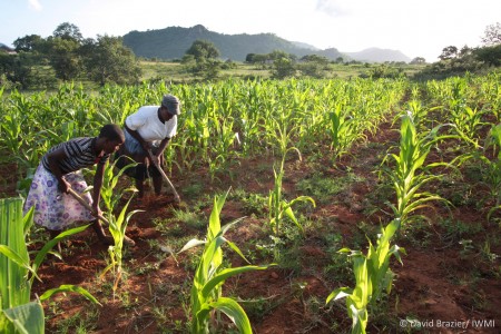


Related publications
Water-related ecosystem services and food security
Coates, D.; Pert, P. L.; Barron, J.; Muthuri, C.; Nguyen-Khoa, S.; Boelee, Eline; Jarvis, D. I. 2013. Water-related ecosystem services and food security. In Boelee, Eline. (Ed.). Managing water and agroecosystems for food security. Wallingford, UK: CABI. pp.29-41. (Comprehensive Assessment of Water Management in Agriculture Series 10)Do ecosystem services influence household wealth in rural Mali?
King Liebenow D., Cohen M.J., Gumbricht, T., Shepherd, K.D., Shepherd, G. 2012. Do ecosystem services influence household wealth in rural Mali? Ecological Economics 82: 33–44. https://dx.doi.org/10.1016/j.ecolecon.2012.08.005.
Many ecosystem services and few employment and marketing opportunities: the paradox of an Andean community in Peru
Blundo Canto, Genowefa; Cruz-García, Gisella S.; Tristán Febres, Maria Claudia; Pareja Cabrejos, Piedad; Quintero, Marcela. 2016. Many ecosystem services and few employment and marketing opportunities: the paradox of an Andean community in Peru. CGIAR Research Program on Water, Land and Ecosystems (WLE).5p.