You may remember in 2003, 2007 and most recently in 2013 when Sudan was hit with devastating flash floods that displaced hundreds of thousands of people. Millions of dollars of aid have been poured into relief efforts. This left hydrologists and remote sensing specialists, like myself, to wonder how we can better prepare and warn farmers of flood events.
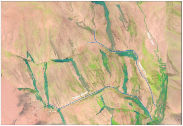 Landsat satellite image showing flood inundation extent for the Degan and Tendali irrigation blocks in the Gash catchment, Sudan. Image: Giriraj Amarnath
Poor farmers need to access real-time information and they need to be able to exchange and apply it. Smart ICT (e.g. cell-phones backed up by the web) can play a fundamental role in the communication process for flood events and can provide quick, real time information on how to best manage flood water for agricultural production. So we decided to connect information on flooding and agricultural water management with a SMS service.
Flooding in the Gash Delta, Sudan
The Gash delta in Sudan is completely dry except for the flood season from July to September. Since farm fields are flooded during this season, farmers need to wait until the soil loses some of the moisture to start sowing seeds. During the 2012 and 2013 flood season, I along with my colleagues from IWMI collected remote sensing satellite data in the Gash basin. On a daily to weekly basis we analyzed images in 5 major irrigation sections of the Gash basin (known as irrigation blocks) that were used to determine the extent and duration of flood waters.
Currently, authorities including irrigation agencies, water users and disaster agencies are not aware of the flood flows from the upstream catchment to the downstream Gash Delta, which often brings catastrophic flooding like those that occurred over the past decade. This is especially concerning since water user associations and field officers control the amount of flood water flowing into farmers’ fields.
Omer Mohammed Ali, Sudanese farmer from the Gash Delta, says that his field was flooded for five weeks. He was surprised that this resulted in decreased crop yields on his land, as he believed that if his field was inundated for a long time, he would be able to get a higher yield. However, our research shows that if farm fields are flooded for more than two to three weeks, it will result in low crop yields, such as Omer experienced. He is one of the farmers in Sudan who is part of our pilot project connecting farmers to information about weather and water use for agriculture through an SMS service.
Flood Forecasting
We are in the process of developing a prototype flood forecasting tool using Hydrologic Engineering Center’s Hydrological Modeling System and River Analysis System. We have also collected data on soil and land cover, and water flow to forecast flood flows at the downstream Kassala Station. Our partners at the Hydraulic Reseach Centre, Gash River Training Unit from Kassala University are currently evaluating the model and are so far optimistic that this information will better prepare farm fields in advance of flood events in order to mitigate damage and improve disaster agency response services.
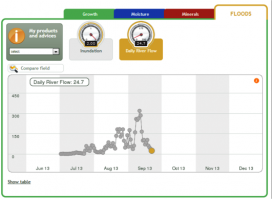 Snap shot from fieldlook portal showing 2013 flood flows on an operational basis: Giriraj Amarnath
By sharing information through an online portal called Fieldlook, irrigation authorities, water user associations and agriculture extension agents will be able to find out if farmer fields have been affected by floods. They will also be able to access and utilize a SMS service that they can use to inform farmers of flood information; and they will be better able to assess how to control the amount and duration of flood water on farmers’ fields, making sure the farmers are getting water at the right place, at the right time and the right quantity.
This type of flood forecasting tool is first of its kind in the region, providing operational flood information services to many farmers in the pilot area using the Smart-ICT SMS Service, which has proven to be the most direct way of reaching farmers.
How do we text farmers?
The complex satellite sensor information and model-derived flood flows are converted into simple text messages to farmers. The texts contain information related to the optimum use of flood water for crop production. For example, inundating fields for too long or too short a period of time will reduce crop yield. So, this SMS service will provide information on the optimum amount of time that fields should be flooded directly to farmers’ phones. The system can also warn farmers of flood events, which will allow them to better prepare their fields.
This information may also mitigate flood damage by better estimating the risk to civilians of future flood events. Our models are able to predict which areas will be flooded and which communities may be displaced. Sharing this type of information on risk areas will help authorities and disaster agencies better target flood mitigation measures.
The successful implementation of this flood-based farming can be very well up scaled globally; for example in an estimated area of 2.0-2.5 million hectares (ha) that is unique to arid regions bordering highlands, common in South Asia, the Middle East, North Africa and the Horn of Africa.
In my opinion this technology can be applied rapidly as there is a large untapped potential to improve food production and livelihoods in flood irrigated areas. So the technology along with models can help farmers get the right quantity of water at right time to inundate the farm fields, improve the crop production and contribute to sustainable livelihoods.
Giriraj Amarnath is presenting this tool at the ICT4Dev Conference (Follow on Twitter #ict4d2014) in Nairobi March 24-28th. View his presentation here.
Related contents
Blog Post 
Blog Post 
Blog Post 


Comments
very interesting information