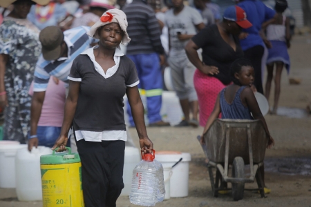
South Africa is defined by both large commercial farming and small subsistence farming, a dynamic environment in which water resource for the agricultural sector are constantly changing. In an effort to focus policies and investment on irrigation and reduction of smallholder farmers' vulnerability, data on irrigation is valuable.
Yet, recent studies reveal that there are many differences in reported numbers of irrigated areas, especially in developing countries. The significant knowledge gaps and uncertainties still remain to be filled to better inform investment decisions and policy making. This is particularly relevant for South Africa, where the National Development Plan (NDP) hopes to increase irrigated areas.
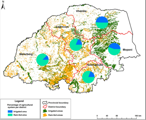
With irrigation integral to South Africa's food security, the compiled maps from IWMI-lead research address the lack of data and a general lack of an accurate, up to date and comprehensive information set for a baseline.
Based on a combination of Landsat and Moderate Resolution Imaging Spectroradiometer (MODIS) satellite data, previous irrigated area mapping exercises carried out by DAFF and three-field ground truthing (GT) surveys, a total of 1.6 million hectares (Mha) of cropland were identified, with 262,000 ha actually irrigated in the 2015 winter season. The study also found that only 29% of all land equipped with center pivots was actually irrigated.
Contacts

Jennie Barron
Jennie Barron was co-leader of the Land and Water Solutions research theme for WLE until Nov. '19 and is a professor in the Deptartment of Soil Science and Environment at the Swedish University of Agricultural Sciences (SLU), Uppsala, Sweden.
Lead Partner
International Water Management Institute (IWMI)Other Partners
Department of Agriculture, Forestry and Fisheries (DAFF) and the Limpopo Department of Agriculture and Rural Development (LDARD)
Related publications
An analysis of methodological and spatial differences in global cropping systems models and maps. Global Ecology and Biogeography
Anderson, W., You, L., Wood, S., Wood-Sichra, U. and Wu, W. 2015. An analysis of methodological and spatial differences in global cropping systems models and maps. Global Ecology and Biogeography 24: 180–191.
Use of remote sensing and GIS tools in the irrigation commands to assist planning and management
CGIAR Research Program on Water, Land and Ecosystems (WLE). 2013. use of remote sensing and GIS tools in the irrigation commands to assist planning and management.Colombo, Sri Lanka: International Water Management Institute (IWMI). CGIAR Research Program on Water, Land and Ecosystems (WLE).Mapping irrigation potential from renewable groundwater in Africa – a quantitative hydrological approach
Altchenko, Yvan; Villholth, Karen G. 2014. Mapping irrigation potential from renewable groundwater in Africa – a quantitative hydrological approach. Hydrology and Earth System Sciences Discussions, 11(6):6065-6097.


Blog Post 
Blog Post /index.jpg?itok=KK_btH_L&c=1e41ff7740f2c7be23dcc40569fe2d59)
Blog Post