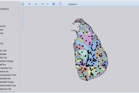
These bulletins brings recent forecast data and monitoring information on irrigation, water, and food security to policy makers across Sri Lanka. Check back in for a new report every three months.
This variety catalogue of notified varieties and promising landraces of eight crops important for the high mountain agricultural zones of Nepal is an important tool for farmers and researchers concerned with agricultural production, food security and agrobiodiversity conservation.
Soil erosion and land degradation are major causes of smallholder vulnerability, reducing crop productivity and increasing food security. This soil information system is an extensive compilation of up-to-date soil fertility data, providing soil fertility maps and fertilizer recommendations.
WA+ is a framework that provides consistent and coherent information on water resources and the services water provides, such as irrigation for agriculture, in a river basin or a country.
WaterWorld is a software tool that aids in developing and assessing water and land-related policies. The web-based tool examines the consequences of development actions through computer simulation, by highlighting their effectiveness and unintended consequences, both locally and downstream, before the options are tested on the ground.
Co$ting Nature is a software tool that aids in developing strategies to sustain and improve ecosystem management. It is being used by WLE in its Volta region work in Africa for ecosystem service trade-off analysis.
The best available data on municipal wastewater production, collection, treatment, discharge and direct use for irrigation purposes is continuously collected and added to AQUASTAT, the FAO global water information system.
The Africa Soil Information Service provides continent-wide digital soil maps and decision-support applications for sub-Saharan Africa, using new types of soil analysis and statistical methods.
 and maize (darker green) above Khudi, Nepal.")