One of the characteristics of WLE target basins is the absence of monitoring systems with the capacity to produce timely and quality data needed to design and implement investments and interventions. This activity aims at developing: 1)low-cost high resolution surveillance platforms for multiple applications and to 2) develop modeling tools to combine high resolution locally registered information with space-borne low-cost medium resolution satellite imageries. The research includes the development of methodologies and manuals to assemble low cost remote sensing devices (e.g. multispectral cameras, micro radiometers, passive fluorescence camera) and the software to make geometric and radiometric corrections and generating mosaics of imageries from contiguous registration. It also includes the development of algorithms to assess and modeling scaling issues. We also propose developing applications and data useful for decision makers such as crop statistics, biodiversity mapping, and agro-ecosystems health assessments. Tools and methods based on non-linear methodologies suitable to process and quantify data collected at different spatial and temporal resolutions will be programmed in open source software, training for end users and policy briefs will be provided as results are confirmed. In addition, the methods developed by this SRP on methods and metrics to help set priorities will be used with policy-makers in Peru to evaluate the impact of the NAMA described under the rainfed systems SRP
Contact Person
Adolfo Posadas (a.posadas@cgiar.org)Lead Center
Related contents
Podcast 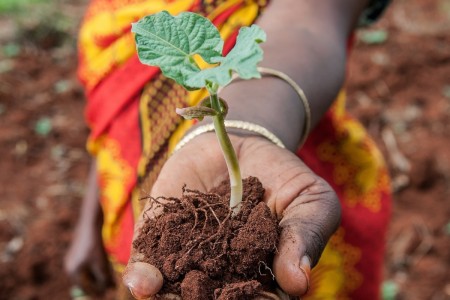
Blog Post 
Blog Post 
Blog Post 


Related publications
A collection of tools for land restoration
Pingault, N., Meybeck, A., Mehmood Ul-Hassan, M., van Noordwijk, M., Minang, P.A. and Gitz, V. 2021. A collection of tools for land restoration. FTA Working Paper 13. Bogor, Indonesia: The CGIAR Research Program on Forests, Trees and Agroforestry (FTA). https://doi.org/10.17528/cifor/008438Sharing research data in a connected world for connected decisions: Lessons learned from the CGIAR Research Program on Water, Land and Ecosystems (WLE)
CGIAR Research Program on Water, Land and Ecosystems (WLE). 2021. Sharing research data in a connected world for connected decisions: Lessons learned from the CGIAR Research Program on Water, Land and Ecosystems (WLE). Colombo, Sri Lanka: CGIAR Research Program on Water, Land and Ecosystems (WLE). 6p. [LEGACY BRIEF 2].Restoring degraded landscapes. A synthesis of evidence generated by the CGIAR Research Program on Water, Land and Ecosystems (WLE) to influence planning, investments, research, practice, capacity and policy
CGIAR Research Program on Water, Land and Ecosystems (WLE). 2021. Restoring degraded landscapes. A synthesis of evidence generated by the CGIAR Research Program on Water, Land and Ecosystems (WLE) to influence planning, investments, research, practice, capacity and policy. Colombo, Sri Lanka: CGIAR Research Program on Water, Land and Ecosystems (WLE). 8p. [LEGACY BRIEF 1].Contour Ridge Tillage for Improved Crops and Fodder Trees Production in the Villages of Kani and Noumpinesso, Southern Mali
Dembele, C. O.; Traore, K.; Karembe, M.; Zemadim, B.; Samake, O. 2021. Contour Ridge Tillage for Improved Crops and Fodder Trees Production in the Villages of Kani and Noumpinesso, Southern Mali. Journal of Agricultural Studies, 9(2):550-572. ISSN 2166-0379 doi:https://dx.doi.org/10.5296/jas.v9i2.18513
Traditional knowledge affects soil management ability of smallholder farmers in marginal areas
Occelli, M.; Mantino, A.; Ragaglini, G.; Dell’Acqua, M.; Fadda, C.; Pè, M.E.; Nuvolari, A. (2021) Traditional knowledge affects soil management ability of smallholder farmers in marginal areas. Agronomy for Sustainable Development 41: 9. ISSN: 1774-0746