

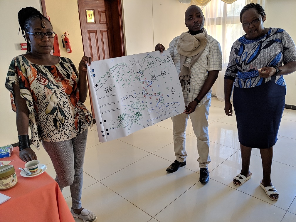
In December of 2018, scientists from the CGIAR Research Program on Water, Land and Ecosystems (WLE) hosted officials from Makueni County for an exchange visit to northern Ethiopia. Together, we explored how integrated landscape approaches helped Ethiopians restore watersheds from degraded desert lands to lush and productive landscapes.
Seeing the integrated landscape approach in action
An integrated landscape approach is defined as a cross-sectoral approach that makes a deliberate effort to achieve many different goals within a landscape through collective action and integrated governance. It simultaneously aims to restore ecosystems, increase agricultural yields and incomes, and improve road infrastructure, irrigation management, and overall quality of life for communities in the landscapes.
With the exchange visit, WLE, together with the World Resources Institute (WRI), aimed to provide Makueni County officials with an opportunity to get hands-on experience with this approach.
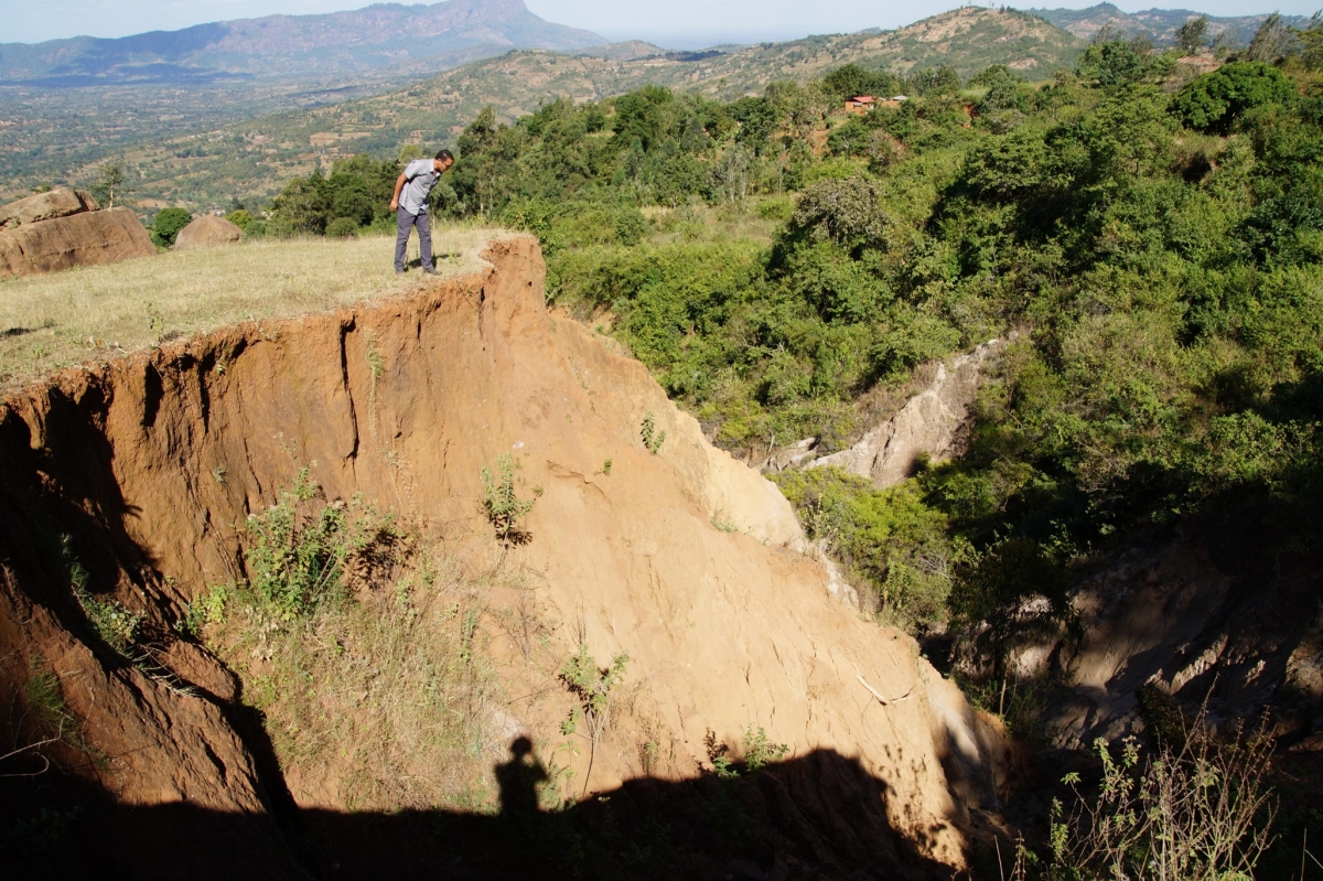
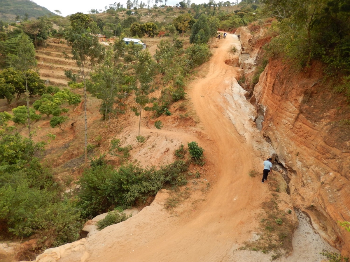
While in Ethiopia, we visited the Agulae, Genfel, and Gule watersheds, taking time to talk to farmers and business people, and also visiting some important cultural sites along the Mekelle-Wukro-Adigrat route, as well as in Axum. We experienced the impact of restoration activities such as area closures, deep trenches, pits and ponds, check-dams, sand-dams and other physical and biological soil and water conservation techniques. Water management and harvesting technologies included river diversions, ponds, micro-dams, check-dams, spate irrigation, shallow wells and pump-based irrigation. Gully curing and land restoration activities were initiated at the hilltop and moved down-slopes. Many interventions were done hand-in-hand with road construction to help people harvest water from roadsides.
Integrated land and water management options were implemented with consideration paid to their position in the upstream-downstream gradient. In the upper section of landscapes without roads, stone/rock barns, deep trenches and percolation ponds were constructed. Area enclosures and afforestation were among the methods employed for soil conservation and moisture management in this section of the watershed. In the middle section of these landscapes, deep trenches, percolation ponds and check dams were also constructed. Conservation practices in this section involved river diversion, area enclosures, afforestation and sinking of shallow groundwater wells. Irrigation was developed in the lower section of the landscapes, with irrigation water being drawn from shallow ground water wells, water storage ponds and stream/river diversions.
In the upstream/up-slope section of landscapes with roads, activities were focused on enhancing infiltration, reducing erosion and conserving the environment. In the down-slope/downstream of these landscapes, efforts were put forward to promote water harvesting, enhance groundwater recharge, and promote sustainable use of water by factoring in water supply and irrigation. Water from culverts was also collected in water ponds to enhance percolation.
Infiltration pans were constructed to collect the excess runoff from stone barns in the up-slope areas for infiltration and percolation, thereby raising the water table. These pans are frequently maintained by repairing and de-silting before the onset of rains. De-silting is done through controlled mining, as the accumulated sand is sold to construction sites, especially road construction, and generates income for the local community.
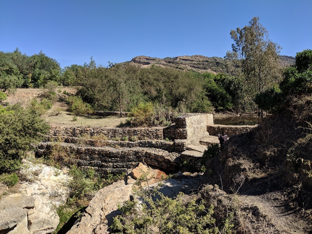
Check dams were constructed across gullies using gabion boxes filled with stones and/or sand, depending on local conditions. Their design and placement enhanced deposition, thus trapping the silt and sand from runoff water. Different grass species and trees are used as vegetation cover in the reclaimed gullies. They control all forms of soil erosion and replenish the soil organic matter. The most commonly used grass species is the Bambusa vulgaris (Bamboo spp.,) while Eucalyptus spp. is also used as a vegetation cover. In some cases income generating options are integrated with biological options to support livelihoods of farmers, mainly the youth.
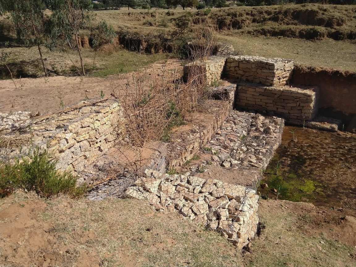

Natural springs occur due to the raised water table and act as a source of irrigation and domestic water supply for nearby urban centers. Open hand-dug shallow wells are sunk to three to seven meters deep, which serve as permanent water sources for subsistence irrigation in the rural areas. The wells are lined with a layer of stone, a locally and readily available construction material, to prevent caving in. Domestic water is drawn from closed wells installed with a hand pump, which makes the water more safe and secure.
Inspired to make change in Kenya
Everyone in the delegation, even people with decades of soil and water management experience, expressed surprise at the scale of impact observed in the watersheds that we visited. “The way the community was mobilized to the extent of having the structures still in place six to seven years later is wonderful,” said Mr. Kanzere Saidi, soil and water conservation officer for Makueni County. The visit made clear the differences between integrated approaches and other approaches to landscape restoration.
Mary Mbenge, Chief Officer for Environment and Climate Change, later said “seeing is believing … a desert turned green. No single well that we saw was dry.”
The 10-member delegation consisted of technical staff, policy makers and managers from different administrative levels and county departments, including those managing the departments on (1) Agriculture, Irrigation, Livestock & Fisheries Development; (2) Water, Sanitation, Environment and Climate Change; and (3) Lands, Mining, Housing, Physical Planning and Urban Development. Technical experts on soil and water conservation and environmental education as well as the county’s GIS Lab also participated.
WLE’s engagement in Kenya includes partnering with the government and other stakeholders to help meet its commitment to the African Forest Landscape Restoration Initiative (AFR100), which aims to restore 100 million hectares of land by 2030. Kenya has committed to restore 5.1 million hectares of forests, range-land and agricultural lands.
The delegation deemed the exchange visit a huge success, creating enormous momentum to implement similar activities in Makueni County. With the continued support from WLE and partners, CIAT will support the county to establish integrated landscape restoration sites in early 2019. The first restored catchment will serve as a learning site and catalyst for others to follow.
Related contents
Blog Post 
Blog Post 
Blog Post 
Blog Post 


Related publications
Together for Research and Development: Sustainable soils for African farmers
CGIAR Research Program on Water, Land and Ecosystems (WLE). 2014. Together for Research and Development: Sustainable soils for African farmers.Colombo, Sri Lanka:International Water Management Institute (IWMI). CGIAR Research Program on Water, Land and Ecosystems (WLE). March 2014Sahel Atlas of Changing Landscapes: Tracing trends and variations in vegetation cover and soil condition
UNEP (2012). Sahel Atlas of Changing Landscapes: Tracing trends and variations in vegetation cover and soil condition. United Nations Environment Programme, Nairobi.
Water smart agriculture
CGIAR Research Program on Water, Land and Ecosystems (WLE). 2014.Water smart agriculture.WLE Issue Breif 5. Colombo, Sri Lanka: International Water Management Institute (IWMI). CGIAR Research Program on Water, Land and Ecosystems (WLE).2pEcosystem services and resilience framework
CGIAR Research Program on Water, Land and Ecosystems (WLE). 2014. Ecosystem services and resilience framework. Colombo, Sri Lanka: International Water Management Institute (IWMI). CGIAR Research Program on Water, Land and Ecosystems (WLE). 46p. doi: 10.5337/2014.229A Protocol for measurement and monitoring soil carbon stocks in agricultural landscapes
Aynekulu, E., Vagen, T-G., Shepherd, K., Winowiecki, L. 2011. A Protocol for measurement and monitoring soil carbon stocks in agricultural landscapes. Version 1.1. World Agroforestry Centre, Nairobi.