
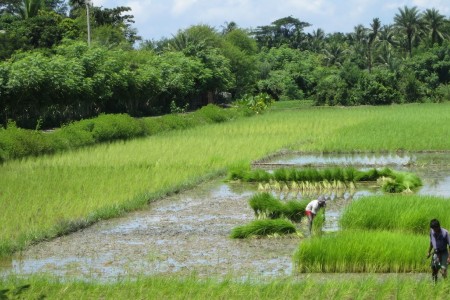
Farming in the coastal zone of Bangladesh is no easy feat. Land there is close to, if not below, sea level and surrounded by a network of tidal rivers that vary seasonally between saline and fresh water. The area is densely populated and more than 80% of people farming in the polders live below the poverty line. While land and water resources are rich, they are underutilized. Areas are occasionally hit by unpredictable and often catastrophic natural events such as cyclones. As sea level continues to rise and the effects of climate change worsen, living and farming in the coastal zone is only predicted to become more difficult.
But many government officials, development agencies and researchers believe that a better future is possible for farming households in the coastal areas of Bangladesh. Attention has turned to a region that once missed out on the productivity boosts and economic development that accompanied the Green Revolution to ensure the country’s future food security. Previous CGIAR research has shown it is possible to greatly increase food production and improve livelihoods with existing advances in crop and aquaculture technologies and available water resources. So what’s holding the region back?

The who, where and when’s of water resources in the coastal zone
The coastal zone of Bangladesh includes 139 polders, low-lying tracts of land surrounded by embankments constructed in the 1960s and 1970s to protect farmers from saline water intrusion and tidal floods. Out of the 2.8 million ha in the coastal zone, almost half (1.2 million ha) are poldered. More than eight million people depend on the land contained within the polders for their food security and livelihoods.
For the most part the polders have been effective in preventing flooding and salinity intrusion, and in protecting people and crops from the worst effects of cyclones. Yet despite past and on-going investments in constructing and maintaining the polder embankments and sluice gates, agricultural productivity is low and poverty is rife. The primary challenge is water management – as a result of the physical environment, the lack of maintenance of the internal polder canals (former natural drains), the conflicting interests surrounding the operation of the sluice gates, and lack of awareness of alternatives.
The operation of the polder sluice gates is a source of much dispute. Who, for instance, has the biggest influence on deciding when and where water is released into the polder or drained from it? Who decides whether to keep water coming in until it reaches the higher lands, while allowing the lower lands to become submerged with too much water? Who decides whether to let saline water in during the dry season or keep it out?
In 2014, building on previous work by the CGIAR Challenge Program on Water and Food (CPWF), one CGIAR Research Program on water, Land and Ecosystems (WLE) project made headway in securing support for a new approach to managing polder ecosystems, one that has the potential to help about 1 million vulnerable farming households in the coastal zone.
“The technical solutions are relatively straightforward: cropping system intensification and improved crop varieties and aquatic species. Two to three high yielding and/or high value crops per year, instead of the current practice of one to two low yielding crops, would be a boon for the region”, explains International Rice Research Institute (IRRI) scientist and WLE researcher Liz Humphreys. “The catch is that successful implementation of those technical fixes is dependent on an accompanying shift in the way water is managed within the polders.”
Problems that arise from the sheer size of each polder and the conflicting interests of those who farm within them are only exacerbated by a lack of clear responsibility and accountability for polder management and maintenance amongst formal government institutions and informal groups. So the project has been working to refine a management approach, first articulated under CPWF, that would make it possible to implement the technical solutions and an institutional mechanism to address additional challenges as they arise.

Co-creating a vision and a process for getting there
In 2014 government officials, elected representatives and members of development projects showed considerable interest in the project’s research findings and recommendations. These recommendations included excavation of silted up drains (canals) and systematic operation of the sluice gate of each sub-polder to remove excess water following heavy rainfall. This would enable the production of high yielding, early maturity varieties of rice during the rainy season and a rapid drainage of water prior to the rice harvest. Most importantly, early drainage would enable a timely establishment of a range of high yield/value dry season crops that could be harvested prior to the onset of damaging pre-monsoon rainstorms and cyclones.
For the benefits of improved operation of the polders to be realized, lands of higher and lower elevation need to be separated and managed as small water management units. Land is already separated to a considerable degree by village and government roads, however, strategic construction of small levees is needed. Finally, improved drainage requires a network of small drains among the farmers’ fields.

One large development program, Blue Gold, has agreed to be directly involved in WLE’s implementation of the above concept by developing the necessary infrastructure within a pilot sub-polder. The WLE project is working with several villages within the sub-polder using a range of approaches and has succeeded in improving both infrastructure and management practices.
In 2015 the project plans to work with approximately 200 farmers in two small water management units to implement infrastructure improvements at the sub-polder level and agree upon a cropping system plan for high yield variety rice and high yield/value dry season crops in each unit.
Says IRRI scientist and WLE project leader, Manoranjan Mondal, “Our hope is to demonstrate the productivity gains and improved water management that is made possible by working with smaller groups of farmers at the sub-polder level. The results and lessons learned from this pilot will be used to inform future discussions with development organizations and government officials about how to improve productivity and livelihoods in the polder zone.”


The polder promise: Unleashing the productive potential in southern Bangladesh
Downloads
Other Partners
The project is led by the International Rice Research Institute (IRRI) in close collaboration with the Bangladesh Rice Research Institute (BRRI), BRAC, WorldFish, Blue Gold, Shushilan and the International Water Management Institute (IWMI).
Related contents
Blog Post 
Blog Post 

Blog Post 
Blog Post 


Related publications
Mining the gaps:using machine learning to map a million data points from agricultural research from the global south
Porciello, J.; Lipper, L.; Bourne, T.; Ivanina, M.; Lin, S.; Langleben, S. 2021. Mining the gaps:using machine learning to map a million data points from agricultural research from the global south. Colombo, Sri Lanka: CGIAR Research Program on Water, Land and Ecosystems (WLE). 22p.
How can economic incentives designed for environmental conservation support a transition to sustainable and equitable agriculture?
Moros, L.; Puerto, S.; Monroy, D.; Achaval-Torre, J.; Rueda, X. 2022. How can economic incentives designed for environmental conservation support a transition to sustainable and equitable agriculture? Colombo, Sri Lanka: Commission on Sustainable Agriculture Intensification. 42p.
Annual report 2021: CGIAR Research Program on Water, Land and Ecosystems
CGIAR Research Program on Water, Land and Ecosystems (WLE). 2022. CGIAR Research Program on Water, Land and Ecosystems 2021 Annual Report: Connected Thinking, Compelling Solutions. Colombo, Sri Lanka: CGIAR Research Program on Water, Land and Ecosystems (WLE). 79p.Integrated rice and fish systems
Dubois, M.; Akester, M.; Ou, P.; Freed, S.; Leemans, K.; Mam, K.; de Silva, Sanjiv; Smith, B.; Teoh, S.J.; Aung, H.M.; Beveridge, M.C.M.; Marwaha, N.; Phillips, M. 2021. Integrated rice and fish systems. Penang, Malaysia: CGIAR Research Program on Fish Agri-Food Systems.Program Brief: FISH-2021-14
Unlocking the potential of flood farming to reduce flood risks and boost dryland production in Ethiopia
Desta, Gizaw; Legesse, Gizachew; Amede, Tilahun; van F.Rooyen, Andre; Whitbread, Anthony. 2021. Unlocking the potential of flood farming to reduce flood risks and boost dryland production in Ethiopia. Colombo, Sri Lanka: CGIAR Research Program on Water, Land and Ecosystems (WLE). 10p.