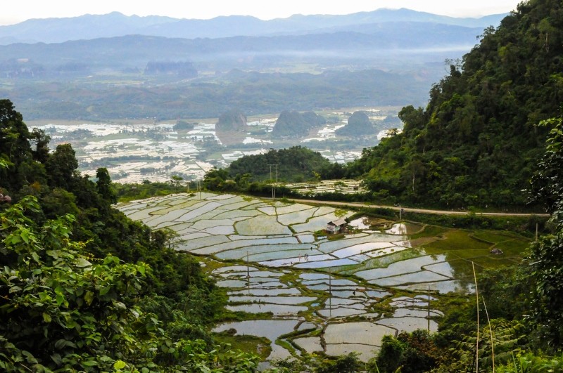
One-third of the world's terrain is considered flood prone; this land also houses 82 percent of the global population. Floods can destroy crops, lives and infrastructure, cause massive displacement of communities and disrupt access to drinking water.
However, floods are crucial to livelihoods in many regions of the world. In the Lower Mekong basin, an area that includes Cambodia, Lao PDR, Myanmar, Thailand and Vietnam, annual flood damage costs $60 million to $70 million, but also results in benefits worth $8 billion to $10 billion. Floods support fisheries and aquatic ecosystems, enrich fields with sediment, resupply underground water reserves and provide an irrigation source for farmers. With the right technologies and access to knowledge, individuals and governments can prepare for, react to and benefit from floods.
Flood risk mapping and analysis
The CGIAR Research Program on Water, Land and Ecosystems (WLE) has developed a flood risk mapping and analysis tool in collaboration with the CGIAR Research Program on Climate Change, Agriculture and Food Security to determine flood-prone areas in South Asia. As part of WLE's Underground Taming of Floods for Irrigation research, the tool is being expanded to Southeast Asia. With the mapping tool, disaster management bodies and other government agencies know where to strategically place upstream floodwater capture systems. These structures store water during the wet season and protect downstream urban areas from flooding,while providing farmers with an irrigation source for the dry season.
Disaster relief
The flood risk mapping tool has also proved relevant for disaster response. In July 2013, heavy monsoon rains arrived early in the northern India state of Uttarakhand, killing 600 people and sweeping away homes and bridges. Researchers contributed to the relief efforts by preparing flood inundation maps.
Researchers captured and mapped the impacts of the floods using satellite images and supplied the maps to the Indian National Disaster Management Authority as well as to the United Nations Office for Outer Space Affairs for wider distribution.
"We were able to provide four maps altogether to the authorities in charge. Our rapid emergency response mapping provides information that can help disaster authorities with relief coordination by giving information about the current flood situation, flood duration [and] flood direction, showing villages and croplands that are affected."
- Giriraj Amarnath, researcher with the International Water Management Institute
Smart ICT solutions in Sudan
In Sudan, a service was established in 2013 to use text messaging to inform farmers about flooding in their area. Further, more than 130 farmers in the Gash irrigation scheme participated in and benefited from using a 'Smart-ICT' platform and online portal called Fieldlook.
Using the online portal, irrigation authorities, water users associations and agriculture extension agents were able to find out if farmer fields were flooded and whether crop productivity was affected. Based on the outcomes, managers of the Gezira irrigation scheme in Sudan are now interested in scaling up the results.
Research continues
WLE will continue its research to reduce negative consequences of floods and utilize the surplus water for development. In Sri Lanka and Myanmar, WLE will further investigate the impact of flooding on agriculture; satellite images will be used to assess recent flood damage and plan flood management interventions. Researchers in Nepal will be monitoring the mountain watershed over a five-year period to better understand opportunities in flood reduction. In Sudan and Nigeria, flood forecasting and research in flood recession agriculture will provide additional insight into managing floods to improve livelihoods. Partnerships with non-government and international organizations, local governments and smallholder farmers will be instrumental for ongoing and new projects.
Other Partners
Collaborating partners: CGIAR Research Program on Climate Change, Agriculture and Food Security
Related contents

Blog Post 

Blog Post 


Related publications
How can economic incentives designed for environmental conservation support a transition to sustainable and equitable agriculture?
Moros, L.; Puerto, S.; Monroy, D.; Achaval-Torre, J.; Rueda, X. 2022. How can economic incentives designed for environmental conservation support a transition to sustainable and equitable agriculture? Colombo, Sri Lanka: Commission on Sustainable Agriculture Intensification. 42p.
Climate migration and social transformation: The case of West Africa
CGIAR Research Program on Water, Land and Ecosystems (WLE). 2021. Climate migration and social transformation: The case of West Africa. Colombo, Sri Lanka: CGIAR Research Program on Water, Land and Ecosystems (WLE). 4p. [WLE BRIEFING SERIES NO. 33]Integrated rice and fish systems
Dubois, M.; Akester, M.; Ou, P.; Freed, S.; Leemans, K.; Mam, K.; de Silva, Sanjiv; Smith, B.; Teoh, S.J.; Aung, H.M.; Beveridge, M.C.M.; Marwaha, N.; Phillips, M. 2021. Integrated rice and fish systems. Penang, Malaysia: CGIAR Research Program on Fish Agri-Food Systems.Program Brief: FISH-2021-14
Unlocking the potential of flood farming to reduce flood risks and boost dryland production in Ethiopia
Desta, Gizaw; Legesse, Gizachew; Amede, Tilahun; van F.Rooyen, Andre; Whitbread, Anthony. 2021. Unlocking the potential of flood farming to reduce flood risks and boost dryland production in Ethiopia. Colombo, Sri Lanka: CGIAR Research Program on Water, Land and Ecosystems (WLE). 10p.
Virtual regional dialogue on options to promote more inclusive weather index insurance
D.Surie, Mandakini; Aheeyar, Mohamed; de Silva, Sanjiv; Raut, Manita. 2021. Virtual regional dialogue on options to promote more inclusive weather index insurance. Workshop summary report[27-28 October 2021]. 35p.